

Airline Maps: A century of art and design
An enjoyable visual book that acts as a history of aviation
From the beginning of scheduled commercial flights for the public, designers have used the excitement and liberation of air travel to inform innovative designs. Airline Maps: A Century of Art and Design collects a diverse range of plans and posters in a book that is truly global in ambition. It covers the period 1919 up to 2019 and includes material published for famous airlines of today and yesteryear. The book illustrates posters, sketches and original artwork for promotional material used by airlines.

The book acts as a history of aviation. We see the birth of commercial carriers using unpressurised biplanes, through the period of colonial consolidation with turbo-prop craft and seaplanes for coastal or island stops through the heyday of national carriers with jet planes up to today’s budget carriers serving tiny regional airports. There is a roll call of lost companies: BOAC, Pan Am, Sabena, Air Ceylon. Imperial Airways embodies in its name and its routes the British Empire as it was it its final decades. Lesser known carriers, such as Iraqi Airways, Hawaiian Airlines, Sudan Airways and Air Jamaica are represented.
Following the end of the Great War, the large number of aeroplanes and trained pilots found employment in postal carriage and – soon after – providing passenger services for the rich. Airfields were designated early and most major cities had landing fields by the early 1920s. Despite being ravaged by war, Europe was eager to take advantage of this new method of fast travel. (By the mid-1930s, Hungary had dozens of regional airports and a dense domestic network of flights.) The fact that the first air-traffic control centre (Newark, New Jersey) was not opened until 1935 is mildly startling. Another striking point is that almost every country in the populated world was connected by flight to others before (sometimes well before) the Second World War. 
Join Britain’s most civilised publication.

Challenge the consensus. Access rigorous analysis.
Critically, the overland air routes through Asia Minor and the Middle East permitted travel from Great Britain to the imperial possessions of Egypt, India, Burma, Singapore, Australia and New Zealand without the slow ocean route through the Suez Canal. The British government formed Imperial Airways in 1924 to provide suitable coverage for such routes. (KLM provided a parallel service from the Netherlands to the Dutch colony of Batavia (Jakarta); likewise Air France and other airlines served the French empire.) The routes show how dramatically air service aided postal communication within colonies, as much as they permitted civil servants and diplomats to reach outposts of empires. Transports Aériens Guyanais provided service between isolated ports in Guyana, Martinique and Guadaloupe, improving communication and travel from 1921 onwards. It was for reasons of prestige, control and reliability that national carriers were established, run or subsidised by governments and granted favoured status for routes.

Some posters offered precise information (Paris to Amsterdam in 2 hours 20 minutes). The Chilean air carrier listed time differences in travel; one leg is marked as 7 hours by plane, 26 hours by train or 6 days by ship. Some of the routes are curious and can be explained by the avoidance of night flying and the limitations of range, but we get some puzzlers. Venice to Klagenfurt? Amsterdam to Hull? Ostend to West Hartlepool?
Designers had to wrestle with displaying global cartography in a comprehensible manner
With relatively few stops and direct flights, some maps could be so simple as to allow artists the chance to embellish with pictorial motifs, even whole pictorial scenes. Broad interpretation, freed of the necessity to show actual routes, allowed illustrators free rein to invent dynamic and exciting compositions in the modernist vein or to incorporate indigenous culture and fauna in more traditional tableaux. The more modern ones still feel daring and invigorating today.
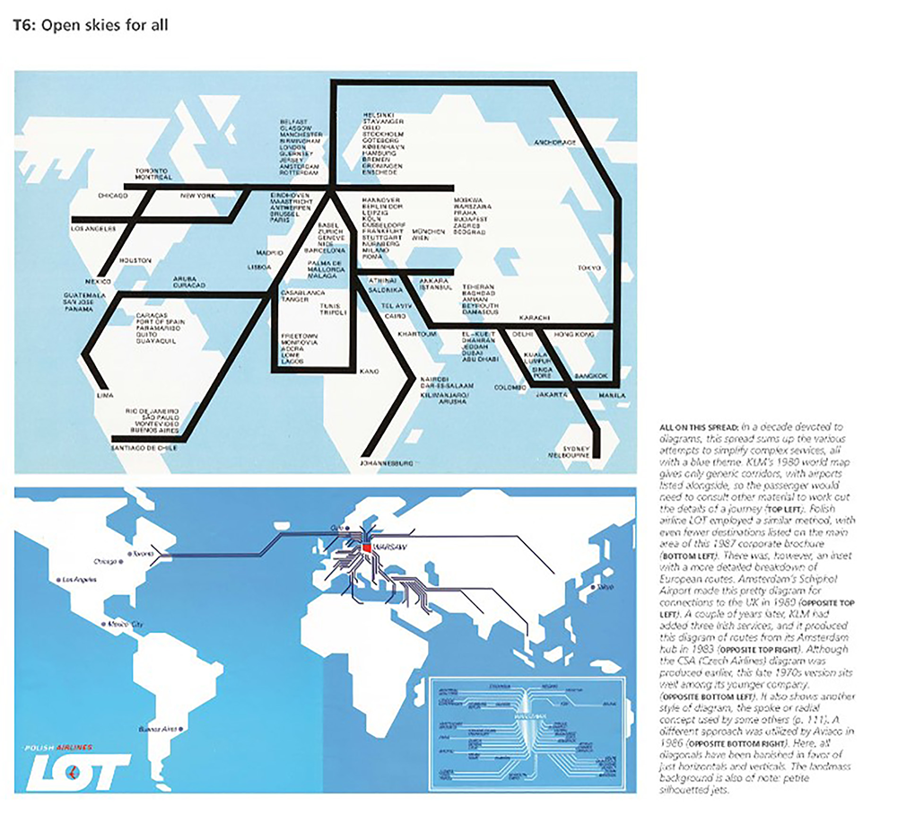
Some of the designs are bold and follow the famous circuit-diagram style of Henry Beck’s London Underground plan. Pan Am produced such a design, which – while eminently clear – is so contrary to our conception of global geography that it feels wrong. Additionally, it fails to visually indicate distance and thus journey time, making it less useful than even the most fanciful and gaudily illustrated map plans. The least suitable and usable plans were those including complicated schedule details and tiny script. Designers for worldwide airlines had to wrestle with how to display global cartography in a comprehensible manner.

The selection forms a history of modern typography, materials and techniques. The matter was printed by lithography and offset lithography but in the early decades the designs were made by hand, often painted in gouache or made using stencils and airbrush. The images chart the rise and fall of fashions. The Art Deco designs for the 1930s were heroic, featuring simplified maps and crisp depictions of flying boats. A 1960 Delta Air Lines map features coloration based on Abstract Expressionist painting. The late 1960s saw new styles of cartoon and psychedelic coloration. In the 1970s photographs became common in advertisements, whilst the route maps became schematic. At their best, these are the easiest to read, even if they lack some appeal as images. To close there is a computer-generated image of the longest-ever non-stop route: London to Perth.
This is an image-led book with concise text but thorough captions. The authors provide information and explain the significance of design choices. There is too much cultural sensitivity on our behalf. “This powerful image of carved wooden African art forces the contemporary viewer to address colonial views of the continent” – well, that is all down to the readers, isn’t it? It would be nice if authors customarily credited readers with more robust discrimination on such matters rather than stepping in to explain to us our own reactions. However grating these few interpolations are, they do not greatly impair enjoyment of this appealing book.


